Mohenjo Daro, which translates to “Mound of the Dead” or “Mound of Mohan,” is an archaeological site located in the Sindh province of Pakistan. Constructed around 2500 BCE, it stood as one of the most extensive settlements within the ancient Indus civilization or Harappan culture, boasting remarkable features like standard bricks, a grid-like road system, and an advanced sewage network.
This ancient city was among the earliest major urban centers globally, sharing historical ties with ancient Egyptian civilizations, Mesopotamia, Minoan Crete, and Caral-Supe.
The decline of the Indus Valley Civilization led to the abandonment of Mohenjo Daro around the 19th century BCE, and the site remained concealed until the 1920s when it was rediscovered. Since then, significant excavations have taken place in the city, earning it recognition as a UNESCO World Heritage Site in 1980. Regrettably, the area is currently facing the threats of improper erosion and misguided reconstruction efforts.
Mohenjo Daro Location
Mohenjo Daro is situated on the western bank of the lower Indus River, within the Larkana region of Sindh, Pakistan. It occupies a location on the Pleistocene plain, which is part of the vast Indus floodplain, approximately 28 miles (17 miles) away from the town of Larkana.
The presence of a well-organized road grid and an intricate drainage system points to the remarkable skills of the ancient inhabitants of Mohenjo Daro, particularly in the realm of water management. However, the exact identity of the people who resided in this ancient city in present-day Pakistan during the third millennium B.C. remains a subject of ongoing scholarly debate and investigation.
Historical context Mohenjo Daro
Mohenjo Daro, founded in the 26th century BCE, stood as one of the largest cities within the ancient Indus Valley civilization, commonly known as the Harappan Civilization, which emerged around 3,000 BCE, stemming from the ancient Indus tradition.
During its zenith, the Indus Civilization encompassed a substantial portion of present-day Pakistan and Northern India, stretching westward along the Iranian border, south to Gujarat in India, and north to the fringes of Bactria. It featured major urban centers like Harappa, Mohenjo-daro, Lothal, Kalibangan, Dholavira, and Rakhigarhi.
Mohenjo Daro was an exceptionally well-developed city for its time, characterized by intricate social engineering and urban planning. However, around 1900 BCE, with the sudden decline of the Indus Valley Civilization, Mohenjo Daro was abandoned.
Archaelogical Significance of Mohejo Daro
The archaeological significance of this site became evident in 1922, a year after the discovery of Harappa. Subsequent excavations unveiled the remains of a city that was once the largest in the Indus civilization. Due to the city’s substantial size, roughly three miles (5 km) in circumference, and the richness of its monuments and contents, it has often been regarded as a potential regional capital. Nonetheless, its relationship with Harappa remains unclear, as it is uncertain whether these two cities coexisted or succeeded one another.
In 1980, Mohenjo Daro received recognition as a UNESCO World Heritage Site.
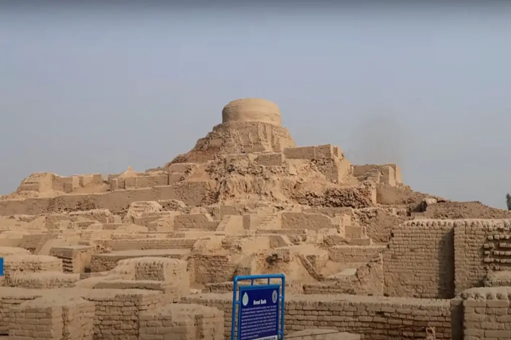
The city’s wealth and opulence are reflected in the artifacts discovered, such as ivory, Lapis, carnelian, and gold beads, as well as in the well-preserved baked-brick structures. Notably, the “Great Bath,” a water reservoir enclosed by baked brick walls, stands as one of the most prominent structures in Mohenjo Daro and is considered a potential site for religious or ceremonial use.
The city was well-equipped with numerous wells, and nearly every house featured bathrooms and a drainage system.
Mohenjo Daro Excavations
Archaeological exploration of Mohenjo Daro began in 1911, with several excavations taking place during the 1920s to 1931. Limited research occurred in the 1930s, followed by further excavations in 1950 and 1964.
Mohenjo Daro was meticulously laid out, resembling a dozen blocks or “islands,” each measuring 1,260 feet (384 meters) from north to south and 750 meters (228 meters) from east to west, separated by straight or dog-legged lanes. The central block on the west side was constructed with large brick walls, reaching heights of 20 to 40 feet (6 to 12 meters), often reinforced with square brick towers.
This high-rise section included a grand bath or courtyard encircled by a veranda, a large residential building, a colossal granary, and at least two adjacent assembly halls. It is believed that the citadel, most likely this section, served as the religious and administrative center of the region. In the lower city, spacious courtyards predominated, catering to the middle class, with many houses featuring compact bathrooms and a plumbing system. Brick floors indicated the presence of upper stories or flat rooftops where residents might have gathered.
The walls of the buildings were originally plastered with mud to mitigate the salt content in the bricks and to withstand varying temperatures and humidity. No written records or inscriptions have been found, and stone carvings are rare, although some surviving pieces include a sculpture of a man with distinct facial features and a figure adorned in a loose-fitting garment embellished with red ornaments.
Notably, a bronze sculpture of a young girl dancing, with multiple arms and a lack of clothing, stands as a remarkable work of symbolic art from the city. The site also houses numerous terracotta figurines, notably those of bulls and buffalo. These figures are often depicted in intricate costumes, and occasionally, the artistry extends to humorous portrayals of small, plump, gender-neutral individuals.
Mohenjo Daro’s history bears witness to several catastrophic floods of unusual depth and duration, which contributed to its demise. These floods were likely triggered not only by the invasion of the Indus but also by the site’s geographical position, situated at the tectonic elevation between Mohenjo Daro and the sea. This evidence has led to speculation that Harappa may have succeeded Mohenjo Daro, or at least followed it.
Today, Mohenjo Daro stands on a raised platform in the modern Larkana region of Pakistan’s Sindh province. Throughout its heyday, from 2500 to 1900 BC, it was a significant center of the Indus civilization, spanning an area of 250 hectares (100 acres) within a series of mounds.
The “Great Bath” and its adjoining structures occupied the longest mound, and over the centuries, these mounds grew ecologically as residents continued to construct platforms and walls for their homes. Despite the absence of regal or royal inscriptions, it is likely that the city was governed by provincial authorities, possibly elected officials or representatives from each of the mounds.
Important Artifacts
In 1926, archaeologists made a remarkable discovery: a small bronze statue of a nude woman, often referred to as the “dancing girl,” which captured their attention.
Jonathan Mark Kenoyer, an archaeologist from the University of Wisconsin, Madison, finds the enigmatic stone carvings of men sitting on thrones particularly fascinating. One such piece, a finely detailed representation of a seated individual, is sometimes referred to as a priestly figure. Yet, intriguingly, there exists no concrete evidence to support the assumption that these figures were priests or rulers.
Kenoyer postulates that a shift in the Indus River’s course might have impacted the local agricultural economy and the city’s significance as a trading hub. However, it is crucial to note that no conclusive evidence indicates that floods were the sole cause of the city’s decline. Moreover, the city was not entirely deserted, and according to archaeologist Possehl, the river’s evolution did not spell the downfall of the entire Indus civilization.